Laurel’s Compass Travel Blog

A travel writer’s guide to adventures of sustainability and spirit

Remembering Martin Luther King, Jr., in Washington, DC

Originally posted: April 2017

On my most recent visit to Washington, D.C., I visited the Martin Luther King, Jr. Memorial in spring. Regal and inspirational, the likeness of this great civil rights leader gazes out over the waters of the Tidal Basin. Sculpted by Chinese master artist Lei Yixin, the memorial is particularly gorgeous when the cherry blossoms are in bloom.

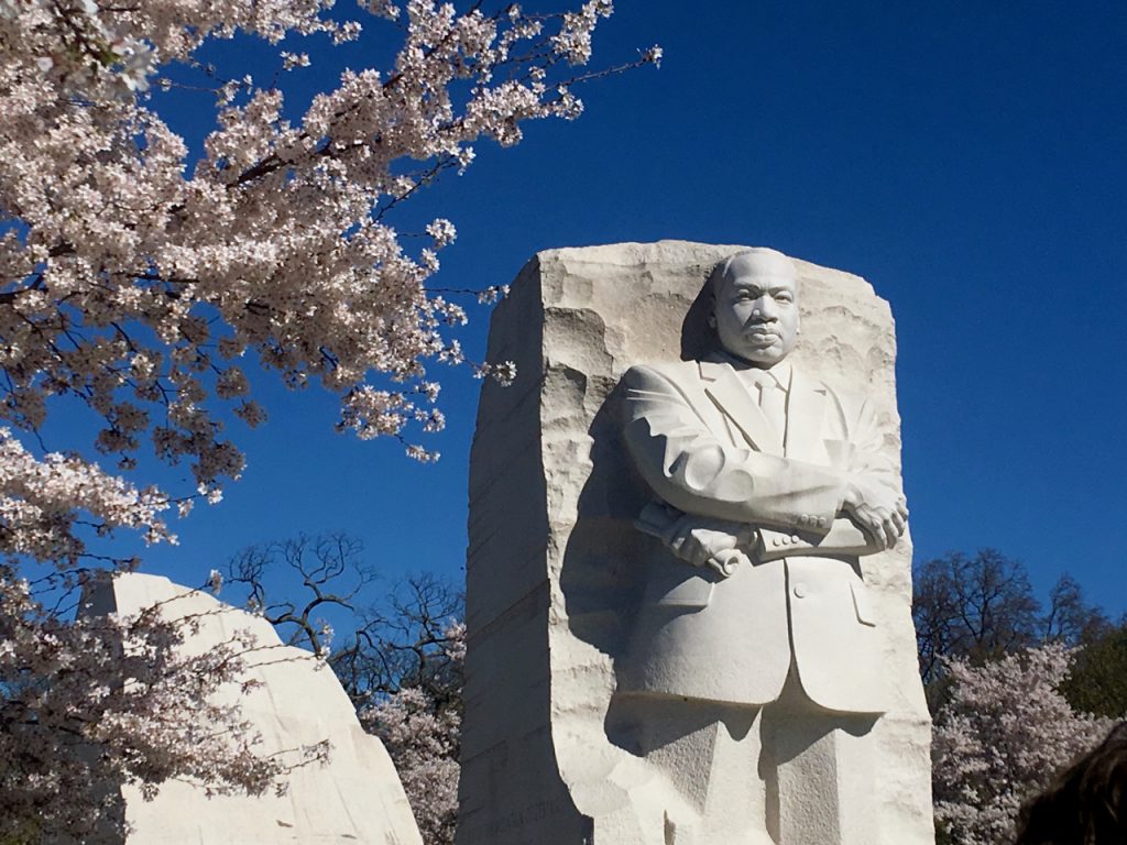
Cherry blossoms decorate the Martin Luther King, Jr. Memorial in Washington, DC. ©Laurel Kallenbach

Dr. Martin Luther King, Jr. was a Baptist minister and social activist who became a world-renowned leader during the U.S. civil rights movement from the mid-1950s until he was assassinated on April 4, 1968. As I stood looking up at the towering statue, I feel intense gratitude for his important work, which changed this nation—even though there is still a lot of work to be done in the United States and worldwide concerning civil rights for all people, regardless of race, nationality, gender identity, ethnicity, and religious belief.

A Message of Nonviolence

Dr. King is the first African-American honored with a memorial on the National Mall. He played a pivotal role in ending the legal segregation of African-American citizens, and he influenced the creation of the Civil Rights Act of 1964 and the Voting Rights Act of 1965. He also received the Nobel Peace Prize in 1964 because he preached and practiced a nonviolent philosophy striving for freedom, justice, and equality.

There are quotes by Dr. King carved upon a wall at the back of the monument. ©Laurel Kallenbach

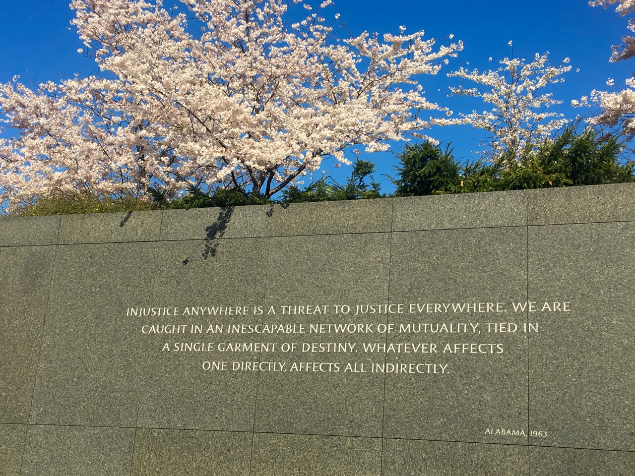
Quotes by Dr. King are carved on a wall at the back of the monument. In this 1963 quote, King said, “Injustice anywhere is a threat to justice everywhere.” ©Laurel Kallenbach

My visit to the memorial was particularly meaningful because I remember the day Dr. King was assassinated—it was my brother’s birthday—and my family watched the funeral procession on TV a few days later. Also, I grew up in Louisville, Kentucky, and in the early 1970s there was a lot of racial tension leading up to school busing to desegregate the public schools. I was shocked when I heard that the Klan was staging rallies; naively I had assumed the days of the KKK were long gone.

Words That Changed America

On a sunny morning during the Cherry Blossom Festival, the monument was buzzing with people from all over the world, speaking numerous languages. I watched as a young Muslim woman had her photo taken in front of Dr. King’s statue. Drummers from the Boulder Philharmonic—who were in D.C. as honorees of the 2017 SHIFT Festival of American Orchestras—played near the monument. Elsewhere, African-style drumming resounded across the Tidal Basin.

"Out of the mountain of despair." ©Laurel Kallenbach

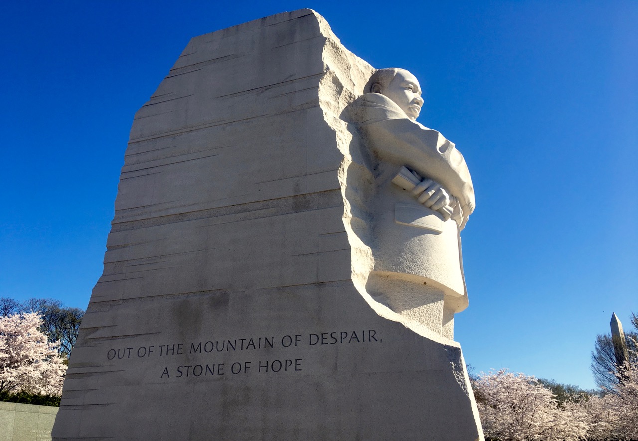
“Out of the mountain of despair, a stone of hope” ©Laurel Kallenbach

On the massive stone behind Dr. King is inscribed “Out of the mountain of despair, a stone of hope,” a line from his 1963 “I Have a Dream” speech.

Behind that is a granite mountain split in half, which some people say represents Stone Mountain in Georgia, the site of a Civil War memorial carved into the side of the mountain. It depicts Confederate leaders Robert E. Lee, Stonewall Jackson, and Jefferson Davis. Stone Mountain is also the place where the Ku Klux Klan was re-founded in 1915. My personal interpretation is that the bisected mountain represents the monolithic block of racism that the Civil Rights Movement cleft in two. Even so, there will always be work to be done in terms of racial justice.

Visitors pored over the quotes from Dr. King's speeches about freedom. ©Laurel Kallenbach

Visitors pored over the quotes from Dr. King’s speeches about justice. ©Laurel Kallenbach

A wall behind the monument is inscribed with words from Dr. King’s speeches over the years, including a famous line that I find so inspiring: “Darkness cannot drive out darkness, only light can do that. Hate cannot drive out hate, only love can do that.”

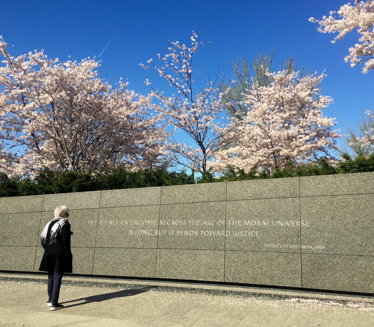
I also loved King’s hope-filled statement, “We shall overcome because the arc of the moral universe is long, but it bends toward justice.” (You can learn more about the quotes at the memorial on the National Park Service website.)

The struggle for civil rights for the descendants of enslaved people will continue, and thankfully the wisdom and vision of Martin Luther King, Jr. will encourage and empower people forever. Having a monument to commemorate one of our most courageous and tireless heroes is a powerful reminder of the conflicts of the past—along with the work that must continue into the future.

The Martin Luther King, Jr. Memorial is part of the National Mall and Memorial Parks, and it is open free of charge. The memorial is located at the intersection of Independence Avenue and West Basin Drive SW in Washington, D.C. Parking is limited near the memorial. The nearest metro stop is Smithsonian.

Originally posted: April 3, 2017

Laurel Kallenbach, freelance editor and writer


An excerpt from King’s “I Have A Dream” speech,  delivered from the steps of the Lincoln Memorial in Washington, D.C., on August 28, 1963:

“One hundred years later [since the Emancipation Proclamation of 1863], the life of the Negro is still sadly crippled by the manacles of segregation and the chains of discrimination. One hundred years later, the Negro lives on a lonely island of poverty in the midst of a vast ocean of material prosperity. One hundred years later, the Negro is still languishing in the corners of American society and finds himself an exile in his own land.”


“Make a career of humanity. Commit yourself to the noble struggle for equal rights. You will make a better person of yourself, a greater nation of your country, and a finer world to live in.” Dr. King spoke these words at the March for Integrated Schools, April 18, 1959) ©Laurel Kallenbach

1 Read More

Whales and Winter Gales along the Oregon Coast

IN WINTER, OREGON’S CENTRAL COAST IS A DRAMATIC PLACE TO WATCH WILDLIFE—ESPECIALLY PEAK MIGRATIONS OF GRAY WHALES AND WILD WEATHER.


During the COVID-19 pandemic, I’m reminiscing about travel adventures of yesteryear. This trip was taken in early January of 2010.

Wind lashed the craggy Oregon shoreline, driving rain in horizontal sheets across my window. In the drab, January-morning light, it was impossible to tell where the steely sky met the pewter sea—yet somewhere out there were gray whales. But where?

A gray whale breaching. Photo Andre Estevez (Pexels)

The whales’ winter migration is the reason my husband and I came to Depoe Bay, Oregon’s whale-watching capital on the central coast. From mid-December to mid-January, the leviathans swim by—as many as 30 per hour—bound for Mexico’s warm waters. Though the whales also cruise these waters during spring and summer, winter is tops for sheer numbers. It also happens to be storm season.

Scanning the watery horizon from our oceanfront rental condo, Ken and I spied a posse of pelicans strafing the waves with their fish-seeking beaks, and sea lions, whose sleek backs flashed in the frothy waves. But no whales.

Sign of a blustery time ©Laurel Kallenbach

After breakfast, we donned raingear and began exploring. Depoe Bay, a charming fishing village 12 miles north of Newport on the Pacific Coast Scenic Byway (Highway 101), sits right on the water. A sea wall runs the length of the three-block downtown, where a geyser-like “spouting horn,” sprays water skyward when waves hit the lava tunnel. We ducked into a handful of gift shops and art galleries to escape the rain. Not surprisingly, the sign at one fishing/whaling charter read: “2 Rough 2 Sail 2 Day.”

Stormy Weather

With damp spirits, we visited the Whale Watching Center in Depot Bay, which is run by Oregon Parks and Recreation. The Center’s museum is packed with information about these marine mammals, which grow to the size of a school bus and eat 1 ton of mysids (tiny shrimp) daily. From the elevated indoor/outdoor viewing station, park rangers answer questions and point out blow spouts (caused when whales surface and exhale). Check in advance for opening times.

Whale Watch volunteer Cheri Bush wore a “Whale Spoken Here” button pinned to her vest. “Two days ago, we spotted 26 gray whales,” she reported. “You need good visibility, because in winter they stay 5 to 7 miles offshore. On a clear day you can see the blows without binoculars.”

Caught by cetacean fever, Ken and I decided to visit the best whale-watching overlooks along the Coastal Highway in hopes that the weather would clear. Of 26 overlook sites in Oregon, eight are clustered between Depoe Bay and Newport. During the annual Whale Week, volunteers stand ready from 10:00 a.m. to 1:00 p.m. to help you spot whales.

A volunteer at Depoe Bay Whale Watching Center scans the horizon for signs of migrating whales as they swim south. ©Laurel Kallenbach

We started at Boiler Bay Scenic Viewpoint, just north of Depoe Bay, where gusts pummeled us with a rain/salt-spray mixture. We peered from under our rain hoods to see a misty bay with a cave and waterfall. A rusted boiler from a 1910 wreck poked from the water, and three wet-suited surfers tested the waves. Under better conditions, this spot would be perfect for detecting whales, but besieged by weather, we soon headed south to the Rocky Creek overlook where we admired the foggy ocean from the car.

Next stop: the ominous-sounding Cape Foulweather. Captain James Cook named this panoramic promontory in 1778—and it certainly lived up to its name that day. Yet, as we beheld miles of coastline, it was easy to imagine whales cavorting offshore. What’s a little rain to them?

A mile down the road was Devil’s Punchbowl, a popular whale- and storm-watching overlook where the ocean slams into a hollowed-out rock bowl. We quickly moved on, wistfully eyeing driftwood-strewn Beverly Beach. On a nicer day, we would have enjoyed walking there, searching for agates.

Instead, we harbored at the Oregon Coast Aquarium (admission fee) in Newport for an up-close view of the ocean world. At the recreated Orford Reef habitat, striped tiger rockfish and halibut with two eyes on one side of their body swam by. In the outdoor pools, sea otters amused us with somersaults; in the aviary, a tufted puffin “flew” underwater.

Yaquina Head and Lighthouse on the Oregon Coast ©Laurel Kallenbach

While we were at the Aquarium, the rain stopped, so we drove to Yaquina Head Outstanding Natural Area (admission fee), another prime whale-watch venue on the Oregon Coast. This narrow spit extends a mile into the Pacific, and an 1873 lighthouse perches atop the basalt cliffs. Yaquina Head affords a 360-degree view, but for a really high vantage point, we climbed the 110 spiral staircase steps to the top of the lighthouse. Cormorants, oystercatchers and harbor seals were some of our sightings—but still no whales. We hiked down to Cobble Beach, where high-tide waves jangled the polished black stones, creating a pebble chorus.

That evening, Ken and I developed an appreciation for storm watching—while soaking in our oceanside hot tub. The rough surf was mesmerizing. “Ooh! Aaaah!” we exclaimed as wave after wave exploded against the rocks, flinging spray high into the air. It was like Fourth of July fireworks created in white sea foam.

Thar She Blows!

On our last day at the Oregon coast, the rain slowed to a drizzle. We decided if the whales wouldn’t come to us, we would go to them. At Dockside Charter on Depoe Bay harbor, grizzled fishermen sat around tables drinking coffee. When we explained we wanted to chase whales, they shook their heads. “Won’t see anything,” they predicted.

Captain Loren Goddard, with Dockside Charters in Depoe Bay ©Laurel Kallenbach

Luckily, Loren Goddard, a captain with a sunny disposition, agreed to take us out in his 33-foot cruiser, Affair. The water wasn’t too rough, and the fog cleared five miles offshore. Loren idled the motor, and we scoured the seas for signs of whales.

There!” I shouted, pointing wildly at a column of spray a quarter mile away. Like a puff of smoke, the blow hung in the air for several seconds, then dispersed. “Good eye!” called Loren. A minute later, we saw another blow. “He’s heading this way,” said Loren. Closer now, the whale’s dark back crested the water again, and we noticed its knobby dorsal “knuckles,” which reminded me of a dinosaur backbone.

Gray whales spouting in the water. Photo courtesy Dockside Charters

Ken and I bounced on our seat like little kids. Minutes later we spotted a pair of blows and tail flukes, and we watched two giants head south in tandem.

“I thought the visibility would be horrid, but we’re right in the middle of whales!” cried Captain Loren.

Over the next hour we saw about a dozen gray whales—none up close or breaching (jumping above water)—but we were thrilled anyway.

The next morning, the rainclouds parted. As we drove north up the Oregon Coast on our way back to Portland, Ken and I stopped at Boiler Bay for a last Pacific overlook, sans gale-force winds. We’d come to the Oregon Coast during winter in the hope we’d catch a glimpse of migrating whales on their way south to Baja for the season. And we succeeded, despite all the inclement weather that came our way. Yet in the process, we made an unexpected discovery: that nature’s wild display of oceanic fireworks was equally satisfying as finding whales in the mist.

Laurel Kallenbach, freelance writer and editor


Beverly Beach, seven miles south of Depoe Bay on the Oregon Coast  ©Laurel Kallenbach

0 Read More

Christmas Past and Present in a Medieval German Town

Esslingen’s Old Town Hall presides over the Medieval Christmas Fair. ©Esslinger Stadtmarketing & Tourismus GmbH

Originally posted in December 2014

December 2021 update: Because of the COVID Omicron variant, this Christmas market, and most others in Germany, have been canceled. 

In an old-town square in Esslingen, Germany, a jester on stilts roams the cobblestones, stopping to juggle and pose for photos with wide-eyed children. Musicians on a stage play ancient, nasally instruments and sing bawdy songs. (Although I don’t speak German, naughty humor seems to be universal.) A woman in a long skirt and laced-up bodice carries a basket of elegant, hand-dipped candles for sale.

Colorful scenes like these unfold before me as I eat homemade suppe und brot—soup and bread—served in handmade crockery bowls in the medieval part of the Esslingen Christmas and Medieval Market.

Medieval drummers and musicians entertain in Esslingen. ©Laurel Kallenbach

Held annually from late November until December 21st, the Medieval Christmas Fair (Mittelalter-märkt) and the traditional Christmas Market have lured me to historic Esslingen am Neckar, a 1,200-year-old town near Stuttgart in southern Germany. Just a 2.5-hour train ride from modern Frankfurt, old-town Esslingen feels centuries away, with its medieval churches and colorfully painted, half-timbered houses with crisscrossed beams.

Esslingen has hosted a Christmas fair since the Middle Ages. Called Weihnachtsmärkte and Christkindlmärkte in German, Christmas markets originated as town fairs as long as a millennia ago so that villagers could stock up on supplies for the oncoming winter.

The medieval streets of Esslingen. ©Laurel Kallenbach

Esslingen is the ideal location for this annual celebration, and I’m among hundreds of delighted visitors exploring the exotic booths and huts in the costumed medieval portion of the market—while also appreciating the Christmasy atmosphere in the “contemporary” part of the market, which itself is actually quite Old World and old-fashioned.

Going Medieval

The Medieval Market—a cross between a Renaissance festival and Christmas fair—has the appeal of craftspeople dressed in period costumes demonstrating revived old art forms and trades. During my two days in Esslingen, I watch calligraphers, candle makers, blacksmiths, knife grinders, soap makers, bakers, tanners, brush- and basket-makers, and mead brewers plying their trades as they might have 700 years ago.

I linger at a number of tents and rustic huts and buy gifts: herb-scented soaps, a fudge-like Afghani sweet called shirpera flavored with cardamom, rosewater, and pistachio. (Such Middle Eastern treats came to medieval Europe via the Silk Road.)

A baker checks on fresh bread baked in a wood-fired oven. ©Laurel Kallenbach

In a special kids’ courtyard, children play Old World games such as hatchet-throwing, egg-breaking, and archery, and they ride a wooden Ferris wheel.

Give Me That Old-Time Christmas

In the traditional part of Esslingen’s Weihnachtsmärkt, rows of wooden huts (called stuben) are so thickly decorated with evergreen and pinecones I think of fairytales—the ones where the forest magically engulfs the kingdom, which sleeps for centuries. If that’s what happened in Esslingen, the town joyfully awakened to celebrate Christmas.

From the elaborately embellished huts, local vendors sell chocolates, pretzels, stollen, wood and glass ornaments, jewelry, and regional specialties such as handcrafted schnapps, honey, jam, and wild boar meat.

A fir-covered “stube” selling candy in the Christmas Market in Esslingen. ©Laurel Kallenbach

Browsing through Esslingen’s traditional Christmas market, I pause to watch as an old man in a Bavarian hat carves a bird. With fine-edged knives spread on his worktable, Helmut Höschle removes bits of wood from the feathers with a surgeon’s skill. His handiwork is quintessential Old World carving, much like the Nativity set my parents have at home—a gift from relatives who brought home figures of shepherds and the three kings decades ago from their travels in West Germany.

Gluhwein mug, Esslingen ©Laurel Kallenbach

Walking through a Christmas Market is a sensory carnival, with elaborate decorations to gaze at, special holiday foods to sample, gifts to shop for, and all manner of music and entertainment.

When you get a bit overwhelmed, it’s time for a mug of glühwein—hot, spiced wine (pronounced “gloo-vine”), which is surprisingly sweet with hints of cinnamon and citrus. It can pack a punch, too, depending how long it’s been since you ate a bratwurst or currywurst.

In Esslingen, there are several glühwein vendors. My favorite is the giant Glühwein Pyramid: an outdoor tavern topped by a giant multi-tiered “carousel” with carved motifs such as angels, snowmen, toy soldiers, or manger scenes and a propeller on top.

The bar also serves beer, alcohol-free drinks, and Kinderpunsch (berry juice for kids). At German Christmas markets, you pay a deposit for the commemorative mug. I keep mine as a souvenir, but you can return the mug in exchange for your deposit.

Time Out from the Market

Thoroughly chilled and footsore from hours of exploring the old town and the markets, I take respite at a 150-year-old Schwaben restaurant (the region where Esslingen is located) called Der Palmscher Bau. 

Closeup of the Pyramid atop the gluhwein bar. ©Laurel Kallenbach

Located in an 18th-century building, its comfort-food recipes, served in rustic-tavern ambiance, are a hit with me. The hot, creamy forest-mushroom soup thaws me out, and I love the Schwabian rostbraten (roast beef) with grilled onions and a dark sauce served with noodles and sauerkraut. (A dry Esslingen Riesling accompanies my dinner, naturally.) For dessert, I choose apple küchle, a roll-up with thin layers of dough and subtly spiced apples. Every sweet morsel gets forked into my grateful mouth.

Even a market as dramatic as Esslingen’s requires a few timeouts from the Christmas revelry. My choice: soak in the natural thermal waters at Merkel’sches Baths and Pool, about 10 minutes away from the Old Town center. The saunas, steam rooms, mineral baths, and massages are divine. (Most Germans don’t wear bathing suits except in the large sports pool. Check the schedule for women-only hours if you’re the modest type.)

I can also recommend yet another diversion in Esslingen: a tour through the fascinating Kessler wine cellars to see how the oldest sparkling wine in Germany is fermented. A guide takes me down into the 13th-century vaults where bottles of the wine ferment. From the damp ceilings, cellar mold hangs like Spanish moss; it’s not cleaned away, the guide explains, because the growth absorbs stagnant air and releases oxygen, which freshens the air.

After the tour, the Kessler tasting room is a delicious revelation. I sip the 2009 Pinot Blanc, and its taste reminds me of apples and herbs—while outside it is the chilly, middle of December. Someday I really must return to Esslingen in the autumn for the grape harvest and the accompanying wine festival.

The chestnut seller peels off the outer husk of the winter treat before roasting. ©Laurel Kallenbach

The Grand Market Finale

After sunset, I pull my wool cap farther down around my ears to keep warm. The smell of roasting chestnuts lures me to a booth where a man calls out to the crowd: “Heisse Marroni! Hot chestnuts!” He removes the lid off the three-foot-diameter pan and stirs the browned chestnuts, their skins popping open.

I buy a paper cone of the hot nuts and gingerly peel one. My fingers blacken from handling the charred skins, but they’re warm. I pop the smoky, starchy chestnut meat into my mouth. It’s bland and dry, but everywhere people are gobbling them, so I figure that perhaps it’s an acquired taste.

After dark, the Christmas Market blazes with colored lights. In the pulse-quickening medieval streets, however, only a few are electric; the rest are flaming torches and braziers, which lend an ancient mystery and romance to the place. Musicians pound on drums while a fire-dancer snaps sparks into the air with his bullwhip. It’s all thrilling and quite dramatic.

Then the church bells peal to announce 5:00 Mass. A crowd forms around the Old Town Hall with its wedding-cake curlicues on the façade and its astronomical clock (built in 1589), which still keeps exact time and displays positions of the sun, moon, and zodiac constellations.

The astronomical clock on the front of Esslingen’s Old Town Hall marks the hour with the animated flapping of the eagle’s wings. ©Laurel Kallenbach

I’m not entirely sure why everyone is gathering, but it doesn’t take long to find out. What everyone is craning to see is the mechanical Imperial Eagle above the clock, which a flaps his wings as the bells ring.

Today’s crowd wears Gore-Tex parkas instead of cloaks and leather leggings and people snap pictures on cell phones. Even so, we’re collectively enthralled by the magic of an antique clock.

It just goes to show that Christmas beauty and merriment have lasted for centuries … and will continue on, I hope.

Laurel Kallenbach, freelance writer and editor

Esslingen Medieval and Christmas Markets: 11 a.m. to 8:30 p.m. daily from late November until a few days before Christmas. Search for information on all of Germany’s picturesque Christmas markets, visit Germany: The Travel Destination.


Read more about Germany’s Christmas markets:

Helmut Höschle, a local woodcarver, works on his beautiful figures in his cheery Christmas hut. ©Laurel Kallenbach

Originally posted in December 2014

2 Read More

Exploring Myth and Prehistory at England’s Rollright Stones

I loved visiting England's Rollright Stones. ©Ken Aikin

I loved visiting England’s Rollright Stones. ©Ken Aikin

October 2021: It’s a great time to reminisce about past travels while most of us stay at home during the COVID pandemic.

Originally posted: September 2018

There are few things I love better than poking about in prehistoric Britain. Located near several of the Cotswolds’ most beautiful villages are one of England’s most charming megalithic sites, called the Rollright Stones.  Not only are they magical, they’re surrounded by colorful stories to boot.

Because our vacation was free from the worries of driving on the left-hand side of the road, Ken and I arranged a taxi from the White Hart Royal Hotel  in Moreton-in-Marsh to the Rollright Stones, which consists of three monuments: the King’s Men stone circle, the Whispering Knights burial chamber, and the King Stone standing stone. Each was built hundreds or thousands of years apart, between 3800 and 1500 years BCE.

The King's Men stone circle in the Cotswolds ©Laurel Kallenbach

The King’s Men stone circle in the Cotswolds ©Laurel Kallenbach

We arrived in the midst of a drizzle, arranged for our driver to return in two hours, and followed the signs through the trees to the largest site, The King’s Men stone circle, where we stood beneath the trees and read the legend of the Rollright Stones from our guidebook.

The tale, which probably dates back to medieval times, goes something like this: A king and his army were marching through the Cotswold Hills when they were changed to stone by a witch—no doubt a wise woman who reasoned that the land was better off remaining as crop- and pastureland instead of becoming a battlefield. So, the crone turned the king into the lone-standing King Stone, his army into the King’s Men circle of stones, and his treason-plotting knights into the Whispering Knights standing stones. The witch then transformed into an elder tree, which supposedly still grows on the hill; if that elder is ever cut, the spell will break, and all the Stones will come back to life.

The King’s Men Stone Circle

The drizzle ceased, and we walked out into the open hilltop to a sweeping panorama of the Oxfordshire/Warwickshire countryside. And then we saw the beautiful King’s Men stone circle, the highlight of the Rollright Stones’ three sites. Dozens of pocked and craggy limestones—most less that six feet tall—stood in circular formation.

The King’s Men stone circle is one of the sites at England’s Rollright Stones. ©Laurel Kallenbach

The King’s Men stone circle is one of the sites at England’s Rollright Stones. ©Laurel Kallenbach

It was easy to see why they’re named for soldiers—many of the more upright stones did seem to have human shapes, although some of them were squat. Each stone possessed amazing character: each was weathered like an aged person’s face. In addition, the stones are covered by unique lichens in many hues—rust, ochre, burnt umber—and according to the info board about the circle, some of those lichens are 400 to 600 years old! The stones are surrounded at their bases by grass, moss, stinging nettles, and tiny field flowers.

Ken beside one of the tallest stones in the King's Men circle ©Laurel Kallenbach

Ken beside one of the tallest stones in the King’s Men circle ©Laurel Kallenbach

Ken and I were roaming alone among the stones, admiring their topography, when we were joined by a quartet of vivacious girls who skipped five or six times around the circle counting the stones.

There’s another legend about the King’s Men stone circle: the stones are supposedly uncountable. There are 70-odd stones, but in places it’s almost impossible to tell where one stone begins and the other ends because they lie in a cluster. Other stones barely show above the ground and the tufts of grass. According to the story, if you count the same number of stones three times, you are granted a wish.

These girls counted the stones in the circle—and got their wish! ©Laurel Kallenbach

These girls counted the stones in the circle—and got their wish! ©Laurel Kallenbach

After the girls had raced around the circle, we overheard them declaring to their mums that they got the same count three times, so they were all making a wish.

After the group left, I began counting stones but was distracted when I looked into the stand of trees that grew in a horseshoe around the circle. In the shrubbery, something shiny and colorful caught my eye, and when I went to look, I discovered that it was clooties—scraps of cloth or other decorations—tied to the branches.

Clooties at the King's Men circle ©Laurel Kallenbach

Clooties at the King’s Men circle ©Laurel Kallenbach

Clooties (also spelled “cloughties” or “clouties”) are a Pagan tradition for honoring trees and asking for healing, and they’re commonly found at sacred sites (like ancient standing stones) and healing wells across the UK and Ireland.

The Rollright clooties were made of ribbon, cloth, stalks of barley or wheat from the surrounding fields, daisy chains, and bits of colorful litter like candy and gum wrappers and a Pellegrino label that the makers probably cleaned up from the vicinity. I imagined that a Pagan group, celebrating Lughnasa just a few weeks before in early August, might have freshly decorated the boughs.

To give thanks for my regained mobility after hip replacement—which made it possible for me to travel to England for a walking holiday—I assembled my own clootie out of dandelions and a spray of leaves, and I tied them to a branch.

Last, I circumnavigated the circle again, counting the stones. I came up with 76, but didn’t have time to do a second or third pass; we still had two more sites to visit before our time was up, so I left it to the mystery.

This stone truly looked like a human outline in the King's Men circle. ©Laurel Kallenbach

This stone truly looked like a human outline in the King’s Men circle. ©Laurel Kallenbach

I did, however, take a moment to try to envision the stones with no gaps between them. According to historical and archaeological documentation, the stones may originally have numbered about 105, all standing shoulder to shoulder—even more like a militia than they look now. Over the millennia, many of the stones have fallen, and some were carted away in the last millennia for use in building bridges and whatnot.

In modern times, the Rollright Stones have been used to exhibit modern sculptures, including Anish Kapoor’s Turning the World Inside Out, and for plays, notably Mark Rylance’s production of The Tempest in1992. The Stones are also regularly used for private wedding and naming ceremonies and other celebrations, according to the Rollright website.

The Whispering Knights

Just a short walk past pastures of grazing sheep are the Whispering Knights. This trio of upright stones is aptly named because the stones lean into each other, so it doesn’t take much imagination to picture them as disgruntled knights furtively colluding against the king.

Three Whispering Knights at the Rollright Stones ©Laurel Kallenbach

The three Whispering Knights at the Rollright Stones ©Laurel Kallenbach

In reality, the vertical stones originally formed a Neolithic portal-dolmen, with these upright stones supporting a capstone, or flat “roof.” Sometime between 3800 and 3500 BCE, builders constructed this portal to lead into a communal burial chamber, which was used for human remains well into the Bronze Age, according to the sign posted at the site.

Today the Whispering Knights are surrounded by an iron fence to discourage people from climbing on the stones and damaging them or the lichens that grow on them. The Knights gaze over the farm fields and stands of trees as far as the eye can see. People toss coins into the crevasses of one of the fallen stones—for luck I suppose. Or perhaps to insure that they will return to this lovely place.

Another view of the Whispering Knights, part of a collapsed passage dolmen. ©Laurel Kallenbach

Another view of the Whispering Knights, part of a collapsed passage dolmen. ©Laurel Kallenbach

The mysterious stones seem to have captured the imagination of people in the region for centuries: There’s an age-old story that on New Year’s Day, the three Whispering Knights hoist their rocky bodies and “walk” down the valley to the brook for a drink of water. The church bells of the nearby town of Long Compton are also supposed to inspire this migration. If ever there were three stones with human personalities, it’s these three.

Other local folklore includes this story: A local farmer wanted one of the largest stones to build a bridge over a stream. It took 24 horses to drag the stone down the hill, and one worker was killed on the way. Eventually the farmer got the stone positioned across the stream, but by the next morning it had flipped over onto the bank! Each time the farmer moved the stone into a bridge position, the same thing happened. Then the area crops failed, so the farmer and his friends decided to return the stone to its original position. This time it took only onehorse to drag the heavy slab back up the hill!

The moral of the story? Don’t mess with ancient megaliths—and never underestimate their power or majesty.

The King Stone

We walked back to the road and crossed, passed through a farm gate, and wandered up to the lone King Stone, which rises sinuously from earth to sky.


The gate leading to the field where we found the King Stone. ©Laurel Kallenbach

The gate leading to the field where we found the King Stone. ©Laurel Kallenbach

Its lovely curve isn’t how the stone originally appeared; its shape is the result of centuries of human vandalism, now hopefully curbed by an iron fence with arrow-shaped spikes at the tops.

According to the sign, 19th century drovers and visitors chipped off part of the stone as good-luck charms and to “keep the Devil at bay.”

Bad luck, if you ask me. In fact, it’s a criminal offence to damage any monument stones like this in Britain.

There’s something lonely and exposed about the solitary King Stone, which looks as if thousands of years of wind passing over the hilltop had unfurled solid rock, sending it sailing skyward into the mottled clouds. Or perhaps the presence of adjacent burial chambers and cairns contributes to the melancholy atmosphere.

The time-swept King Stone ©Laurel Kallenbach

The time-swept King Stone ©Laurel Kallenbach

Or, maybe it’s the scale of time at the Rollright Stones: We humans have a lifespan of a hundred years if we’re lucky, whereas the King Stone has been a sentry over these Cotswold hills for more than 3,500 years. The Whispering Knights have guarded their secrets for almost 6,000 years.

After two hours at the Rollright Stones—which slipped by in the blink of an eye—our taxi driver returned to whisk us along the country roads and back to our hotel, which has been operating as an inn since the 1600s. Such is time in the ancient lands of Britain.

Laurel Kallenbach, freelance writer and editor

The entrance fee to the Rollright Stones is just 1£. For more information, including instructions to get to the site, visit RollrightStones.co.uk.

More about megaliths:

The circle at the Rollright Stones in the Cotswolds ©Laurel Kallenbach

The circle at the Rollright Stones in the Cotswolds ©Laurel Kallenbach

6 Read More

Musings from Cotswold Trails: Naunton & Guiting Power

We hiked along the Gustav Holst Way on today’s Cotswold trek. ©Laurel Kallenbach

August 2021: It’s a great time to reminisce about past travels while most of us stay at home during the COVID pandemic. 

Originally published: September 2017

Day 3 of our English countryside walking adventure (arranged by Cotswold Walks)  happened to be my birthday, and the 6.5-mile route from Bourton-on-the-Water to Guiting Power held many delights.

Much of our path during the day followed the gentle River Windrush, which sometimes seemed to be more of a brook than a river.

At the beginning of our morning ramble, a swan flapped over the field we were walking through as it descended for a water landing. The air on the magnificent white bird’s great wings made a hollow, whooshing sound. I don’t recall ever seeing swans flying before, so this long-necked bird seemed like a good-luck omen for the day.

That was fortunate, because about an hour later Ken and I encountered gigantic cows with sharp horns. They grazed peacefully on the opposite side of a wire fence and the Windrush, which had dwindled to ditch size, but their gazes seemed hostile. We stopped to take a picture, but a mean-looking bull took offense and started advancing toward us as if he meant business, so we moved along quickly.

The hills overlooking Naunton ©Laurel Kallenbach

Today the terrain became more hilly and scenic, and flat fields gave way to woodland. And imagine our delight when we discovered that we were walking on part of the 35-mile trail way called the Gustav Holst Way, named for the composer who’s best known for The Planets. Born in the Cotswolds, Holst spent much time—like us—ambling through the hills and countryside of this region, which he memorialized in his pastoral “Cotswolds” Symphony in F major. (I’m listening to it as I write.) I got so carried away singing the Dargasson jig tune from Holst’s St. Paul Suite that we missed one of our turns.

The sign to Taunton ©Laurel Kallenbach

The sign to Naunton ©Laurel Kallenbach

We didn’t go far off course—less than 50 yards, thanks to the detailed instructions provided by Cotswold Walks—so we quickly got back on track again, and soon I was humming the “Greensleeves” theme that weaves through the end of that piece. (Yes, the Cotswolds Way has great appeal for classical music geeks like us!)

A Rest in Tranquil Naunton

Hiking up and down hills offered us the chance to take in the impressive vistas of medieval villages from a higher vantage point. We met a couple, who were also doing the Best of the Cotswolds circuit, so we hiked with them for about half an hour on the trail that morning. Just before noon, our little group spotted Naunton and decided to have a quick look-around at this town of about 300 people.

A house beside the River Windrush ©Laurel Kallenbach

A house beside the River Windrush ©Laurel Kallenbach

As we arrived on foot, we first saw a large dovecote, a structure with 1,176 dove-sized holes that dates back to the 1600s. (The Cotswold Walks guidebook said that back in the day, the meat of young doves was a dish for the wealthy, so that accounts for the popularity of names like “Dove Cottage” and “Dove Lane.”)

The sign for the Black Horse pub in Naunton ©Laurel Kallenbach

Naunton sits in the valley beside the River Windrush, and there’s a very pretty path right along the water with willows and lots of lovely riverside cottages to admire.

Ken and I sat along the banks for a rest and nibbled on snacks, then we wandered over to the Black Horse Inn, a traditional pub where our friends decided to have lunch. We didn’t eat there because we’d planned to have a late lunch at the next village.

Keep on Trekking

Refreshed, we continued on toward Guiting Power (pronounced “GUY-ting”).  Ken and I crossed through a pasture where a horse followed us all the way to the gate. I think she was hoping we had a treat, but we’d already eaten our snacks. For a while we had a light drizzle—almost more of a heavy mist—that warranted our rain jackets for 10 minutes or so.

Hollyhocks in front of a cottage built from Cotswold stone ©Laurel Kallenbach

Hollyhocks in front of a cottage built from Cotswold stone ©Laurel Kallenbach

Right at 2:00, the Warden’s Way path took us through a cornfield where the tassels were as tall as Ken. When we emerged from the stalks, we caught our first glimpse of the crenelated tower of Guiting Power’s Anglican church, St. Michael and All Angels, which dates back to Norman times. Sheep were grazing in the surrounding pastureland, and though it was tempting to stop and admire, we vowed to return later because we were famished and in need of a beer.

We checked first at the Farmers Arms, a traditional-style pub that served things like fish-and-chips with mushy peas and steak-and-kidney-pie, but the kitchen was already closed. So we kept walking up the hill to the Old Post Office, which has a café, but it didn’t serve hot food after 2:00. So we vowed to return at teatime and continued up the road to the Hollow Bottom Inn, located on the edge of town with views over pastoral fields that were bordered by traditional, drystack-stone fences.

The postmistress took a break at the Old Post Office in Guiting Power. ©Laurel Kallenbach

The postmistress took a break outside the Old Post Office in Guiting Power. ©Laurel Kallenbach

This more contemporary gastro-pub serves some chef-inspired creations. We started with a local microbrew ale and then ordered a perfectly spiced (with tarragon, we surmised) Coronation Chicken Wrap and salads filled with the bounty of local gardens in late August. (Many restaurants in the Cotswolds serve local and organically produced food.)

The menu also offered an interesting story about the origin of the phrase “wet your whistle.” Apparently during the Middle Ages English pubs served ale in ceramic mugs that had whistles baked into them. When you needed a refill, you blew the whistle so the barmaid would come and “wet your whistle.” True tale or just pub lore? Either way it’s a fun story.

St Michael's and All Angels presides of the village of Guiting Power. ©Laurel Kallenbach

St Michael’s and All Angels presides over the village of Guiting Power. ©Laurel Kallenbach

While we were eating, the couple we’d hiked with that morning checked into the inn. Whimsically, we wished we were doing the same, but because it was the day before Bank Holiday weekend, Guiting Power’s modest number rooms were booked months in advance, so we were being picked up by a taxi and returned for the night to Bourton-on-the-Water at 6:00.

(There were pros and cons to this arrangement. On one hand, it was more efficient because we didn’t have to pack up our suitcases before departing on our morning walk. And we didn’t waste time settling into a new hotel or B&B. However, we also didn’t have the experience of spending the night in this distinctly cute town.)

A pretty blue doorway in the Cotswolds village of Guiting Power, Gloucestershire ©Laurel Kallenbach

The Glorious Village of Guiting Power 

After lunch, Ken and I explored Guiting Power, a sleepy, two-street village with just a few shops, the two pubs, a town green, the café/tea shop/post office, and a handful of pretty stone houses. The “tourist” description of Guiting Power is that there’s not much to do there other than have a pint and a bite, but the fact is that we love little towns like this that slumber under the sun on a late-August day.

In fact, I will say it: When I’m in love with a village, I just know I belong there, and Guiting Power stole my heart that afternoon.

Maybe it was the way hollyhocks and roses and purple flowers framed the doorways and windows of those stone cottages, attracting buzzing bumblebees and flittering butterflies.

Toasting my birthday at the Old Post Office ©Ken Aikin

Toasting my birthday at the Old Post Office ©Ken Aikin

Maybe it was the sheep grazing in the pastures around the church as we sat in the cemetery and gazed upon the countryside.

Maybe it was the joy of having chocolate cake and a birthday cappuccino at the outdoor table at the Old Post office while watching the locals  walk their dogs. We bought some stamps and basked in the sun and wrote  postcards.

Really, that’s about all Guiting Power had to offer—and it was heaven. No traffic. Very few tourists. Just the simple joy of spending a quiet afternoon in the prettiest of Cotswold villages. And lots of beautiful flowers.

Flowers Guiting Power ©Laurel Kallenbach

Brilliant flowers in the village of Guiting Power ©Laurel Kallenbach

Guiting Power was exactly what Ken and I had dreamed of when we were planning our walking trip through the Cotswolds: and here we were at this perfectly perfect village on my birthday! I can’t imagine a better present.

Laurel Kallenbach, freelance writer and editor

Read more about my Cotswold hiking trip:

More about my travels in England:

I couldn't help but hum Bach's "Sheep May Safely Graze" when I beheld this view. ©Laurel Kallenbach

I couldn’t help but hum Johann Sebastian Bach’s “Sheep May Safely Graze” when I beheld this pastoral view on the edge of Guiting Power. ©Laurel Kallenbach

0 Read More

Canada Reopens Borders to American Travelers

There’s good news for American vacationers who have missed traveling due to the pandemic: Effective August 9, 2021, fully vaccinated US citizens and permanent residents (who currently reside in the US) can enter Canada for leisure travel. If they meet the entry criteria, travelers with proof of full coronavirus vaccination will not be required to quarantine upon arrival in Canada.

Jetty at Limberlost Lodge in Ontario’s Algonquin Park (Almaguin Highlands, Muskoka and Parry Sound) © Destination Ontario

This means that the welcome mat is out for Canada’s awe-inspiring destinations—from Newfoundland in the east to the Yukon Territory to the west. In between are thousands of miles of cities and wilderness to enjoy, including historic Québec City, the lakes of Ontario, the Canadian Rockies, and Vancouver Island on the western coast.

Entry Information and Exemptions for Fully Vaccinated Travelers

To qualify for the fully-vaccinated traveler exemption, you must:

  1. have no signs or symptoms of COVID-19
  2. have received the full series of an accepted COVID-19 vaccine or a combination of accepted vaccines (Pfizer-BioNTech, Moderna, AstraZeneca, and Janssen/Johnson & Johnson).
  3. have received your last dose at least 14 days prior to the day you enter Canada. (For example: If your last vaccine dose was received anytime on Thursday July 1st, then Friday July 16th would be the first day that you meet the 14-day condition.) Visit the government of Canada’s “COVID-19: Travel, testing, quarantine and borders” webpage for more info.

Old Town Québec and the five-star Fairmont Le Château Frontenac Hotel: © Andy Vathis, Office du tourisme de Québec

If you qualify for the fully-vaccinated traveler exemption, you are exempt from:

  • quarantine
  • hotel stopover (for air travelers)
  • the Day-8 testing requirement

To make it easier to prove your vaccination status and qualify for the traveler exemption for quarantine, use an app called ArriveCAN to provide mandatory travel information before and after your entry into Canada. You can upload proof of full vaccination on ArriveCAN so that your travel experience goes smoothly. (ArriveCAN is available for iOS, Android, and online.)

Enjoying Your Visit to Canada

Once you’ve arrived at your destination in a beautiful Canadian province, here are some guidelines for traveling healthily and courteously in our neighboring country. The following tips are suggested by Destination BC (British Columbia), but they apply to travel throughout the country.

The Canadian Rockies, Alberta ©James Wheeler/Pixabay

What Health & Safety Measures Can Americans Expect in Canada?

  1. Masks are recommended in all public indoor settings for people age 12 and older who are not yet fully vaccinated. Many people who are fully vaccinated may still choose to wear a mask.
  2. Some businesses have additional individual health and safety measures in place, such as use of sanitizing stations, physical distancing requirements, and mask requirements.
  3. Steer clear of natural disasters. Summer wildfires or a tsunami could impact your travel plans. To prepare, check conditions in advance at your planned destination. For instance, the Canadian province of British Columbia has a website that offers fire and tsunami warnings and evacuations so that you can plan accordingly.

    Canada is a famous destination for viewing the aurora borealis, also called the Northern Lights © Leonard Laub/unsplash

 Be Respectful When You Travel

All visitors should respect the policies that are in place nationally, locally, and at individual businesses or communities, including Indigenous/First Nations communities. Although some communities are eager to welcome visitors to support their local economy, some rural and Indigenous communities may be hesitant.

Anyone who seeks recreation, hunting, or fishing in Canada should do their research before leaving home so they can respect and abide by local wishes, advisories, and guidance of these communities.

Whale watching for orcas in the waters around Vancouver Island is a popular activity. Photo Destination BC ©Reuben Krabbe

Amid all the changing rules about travel in the era of the coronavirus and the delta variant, remember that Canadians are eager to share the marvels and glories of their country with you. Show your appreciation of their hospitality.

Happy, healthy travels!

Laurel Kallenbach, freelance editor and writer

Read about some of my travels in Canada:

Surfing in Cox Bay, Tofino, BC, on Vancouver Island. Photo courtesy Destination Canada ©Brian Caissie

0 Read More

Winchcombe: This Cotswolds Village Is a Hub for Hiking

The Cotswolds Hills in west-central England are famous for quaint villages, thatched-roof houses, and grazing sheep—and I’ve always wanted to visit the area. The town of Winchcombe called me and Ken, and as luck would have it, we ended up visiting in August of 2012 and again in August of 2017 (as part of our ten-day Cotswold Walks village-to-village walking tour). It was a delight on both occasions!

Winchcombe: a historic town in the Cotswolds ©Laurel Kallenbach

Though I love visiting museums and enjoying the arts in big cities, I am, at heart, a village lover. So a day-visit to Winchcombe, a Gloucestershire village with Tudor-era history, was a match made in heaven.

The town has old buildings, beautiful gardens, a picturesque location, plenty of hiking and rambling trails into the gorgeous countryside, and historic Sudeley Castle. The only thing that wasn’t absolutely perfect when we visited in 2012 was the weather—but even rain didn’t dampen our spirits at this lively village, which dates back in the Neolithic period when people settled in this hilly area and built a stone-lined, burial chamber: the Belas Knap long barrow. (Though I’m keen on Neolithic sites, I still haven’t made it to Belas Knap.)

The Happenstance Border Morris Dancers led the procession through the streets of Winchcombe. ©Laurel Kallenbach

As luck would have it, we arrived in Winchcombe on the day of the Country Show, held annually in late August. A troupe of morris dancers wearing feathered bowler hats, tattercoats, and bells on their shins paraded through the streets, followed by septuagenarians driving vintage tractors. We felt like we were part of the party, which includes a flower show, a test of the skill and speed of herding dogs, sheep shearing, and much more.

Morris dancers entertained in the streets of Winchcombe. ©Laurel Kallenbach

We ate lunch at The White Hart Inn, a 16th-century pub with rooms right on Winchcombe’s main thoroughfare. With lots of country pub atmosphere, The White Hart restaurant is called Wine & Sausage, but it offers much more: In fact, it specializes in local produce cooked into simple but flavorful British food. We tried the regional cider and beer, of course!

I ordered the delicious local lamb served with rosemary/garlic sauce and colcannon, while Ken sampled the traditional fish pie with purple sprouting broccoli. We both were now fortified and ready to ramble.

Winchcombe Welcomes Walkers

The Cotswolds has been crowned the Walking Capital of England, and the 102-mile Cotswold Way footpath takes through-hikers from Chipping Campden to the city of Bath.

Ken on the world-famous Cotswold Way footpath. ©Laurel Kallenbach

Winchcombe is one of the jewels of the Cotswold Way, although it has many other trails as well, including the long-distance Winchcombe Way, the Wardens Way, and and the Windrush Way. The circular Gloucestershire Way also passes through Wicnhcombe and finishes at Tewkesbury.

Our plan was to hike for a couple of hours on one of the many trails that intersect in the village of Winchcombe. So after lunch, we set out on the Cotswold Way footpath, despite dark skies and threatening clouds. We had barely left town when it started to drizzle, but doggedly we on we pressed up the hill. When the rain got heavier and was propelled by high winds, we finally gave up and  turned back toward town.

A Visit to Stately Sudeley Castle

The consolation prize for having our hike rained out was ancient Sudeley Castle, the home of Katherine Parr, Henry VIII’s sixth wife—and the only spouse who officially became that monarch’s widow. (The queen was born 500 years ago in 1512.)

Sudeley Castle’s tower and garden ©Laurel Kallenbach

Between rains, we wandered through the sculpted yew trees and the herb and rose gardens; we rested beside an elegant fountain; we explored the hollyhock-enhanced ruins of an old tithe barn, used in medieval times to store the produce that farmers brought as their tithe to the church. Cromwell partially destroyed the barn during the English Civil War.

For more than 20 years, Sudeley’s groundskeepers have been gardening organically and creating niche gardens and ponds that support native wildlife, including toads, bee orchids, disease-resistant elms, bumblebees, dragonflies, kingfishers and nuthatches.

Hydrangeas at St. Mary’s Church on the grounds of Sudeley Castle. Queen Katherine Parr is buried in the chapel. ©Laurel Kallenbach

We also visited the 15th-century St Mary’s Church where Queen Katherine lies buried.

Inside the castle, we learned about the inhabitants of this castle, from Katherine Parr to its current occupants, Lord and Lady Ashcombe. We especially appreciated an exhibit about the family’s campaign to protect badgers in the region. (They adopted an orphaned badger in the 1960s and ’70s, and have been advocates of the animals ever since.)

Ken and I absolutely loved Winchcombe, and in the summer of 2017 our dream of hiking the Cotswold Hills came true. Fare thee well, little Cotswolds village—we hope to be back again for a third visit!!

Laurel Kallenbach, freelance writer and editor

Originally posted: June 2013

Updated August 2021

For more information about walking in and around Winchcombe, Gloucestershire, visit Winchcombe Welcomes Walkers.You can also search for or share walks throughout England, Scotland, and Wales on Visorando. Key information such as distance and elevation are provided, and you can print out the walk or download a GPX file for use with GPS devices. Here’s the link for Cotswold treks

If you’d like a guided walking vacation—or one where you guide yourself but a local company creates the route and arranges reservations at B&Bs in the Cotswolds—I highly recommend Cotswold Walks, which we used for hiking village to village in 2017.

  • Cotswold Walks: Andrew Guppy offers guided and self-guided walks with great itineraries through the gorgeous Cotswold countryside and towns. They pick up your luggage after breakfast and deliver it to your destination, where it will be waiting when you arrive after the day’s hike.

In honor of Queen Elizabeth’s 2012 Diamond Jubilee, flags were flying in the pretty village of Winchcombe. ©Laurel Kallenbach

Read more about England’s pretty Cotswold region:

Sudeley Castle is located on the outskirts of Winchcombe. It offers gorgeous gardens and stunning views of the Gloucestershire Cotswolds. ©Laurel Kallenbach

12 Read More

Wandering the “Venice of the Cotswolds”: Bourton-on-Water

The banks of the River Windrush are lined with restaurants in Bourton-on-the-Water. ©Laurel Kallenbach

The banks of the River Windrush are lined with restaurants in Bourton-on-the-Water. ©Laurel Kallenbach

July 2021: With the COVID pandemic keeping many of us at home, now is a great time to reminisce about past travels.

As of this posting, visits to England are allowed, but COVID tests and a 10-day quarantine in your hotel is required upon arrival.)

Originally published: October 2017

My husband and I arrived by foot from Lower Slaughter in Bourton-on-the-Water—yet another lovely town in the England’s Cotswold Hills. It was 4:30 p.m., which seemed to be the tourist rush hour. All the tea shops were overflowing with people sipping Orange Pekoe or cappuccinos and forking down fresh-baked cake. An entire busload of visitors was huddled en masse to get their picture taken on one of the picturesque footbridges that arch over the River Windrush. Their guide was wading in the river, hamming it up. What had we stumbled into?

Hydrangeas, Bourton-on-the-Water ©Laurel Kallenbach

Hydrangeas, Bourton-on-the-Water ©Laurel Kallenbach

While it’s true that Bourton-on-the-Water is a popular spot, I have to admit that once again, town emptied out by 5:30, and everything got a lot quieter—and considerably prettier and more enjoyable.

A bit footsore, Ken and I found a bench with a lovely view of the river with its bridges, which give this town its “Venice of the Cotswolds” name.

We watched little kids play in the sleepy river. A miniature boat race—featuring homemade crafts constructed out of leaves and anything folks could find—was taking place.

It felt wonderful just to sit and drink in the ambiance of the place. No rushing, no worries, no ponderous thoughts—other than wondering where we would eat that night.

Ken just loved the regionally brewed beer at the waterside Kingsbridge Pub. ©Laurel Kallenbach

Ken just loved the regionally brewed beer at the waterside Kingsbridge Pub. ©Laurel Kallenbach

Soon our stomachs propelled us in search of food and drink. After checking menus at several of the many eateries, we settled on the riverside Kingsbridge Pub and thoroughly enjoyed a fantastic Hobgoblin IPA (from the Wychwood Brewery in nearby Oxfordshire), which we sipped on the outdoor patio. Although the Chicken Tikka Curry wasn’t quite as memorable, the views of the water in the golden light of early evening more than compensated.

Our accommodations in Bourton-on-the-Water were at The Lawns B&B, hosted by the affable owner, Angie. We had a spacious room, which was quiet and restful, despite the B&B’s location by a fairly busy highway. (It was also a 10-minute walk from the center of town, which wasn’t a problem, but we were a bit tired of walking by that point.) Some aged sheep in retirement—put out to pasture, so to speak!—grazed right outside our window.

Angie’s delicious English breakfasts were cooked to order—a Continental breakfast was also on the menu—and everything was served in the home’s cheery dining room.

A tradesman's sign for the town goldsmith. ©Laurel Kallenbach

A tradesman’s sign for the town goldsmith. ©Laurel Kallenbach

It was a pleasure to spend two nights at The Lawns, especially because we had space to spread out. It also meant we didn’t have to unpack and pack again in the morning. Because it was nearing Bank Holiday, when inns and bed-and-breakfasts fill up, we walked to the next village, Guiting Power (see my next post), and were picked up by a taxi service and returned for the night in Bourton-on-the-Water.

Click here for more information about Cotswold Walks, the company that arranged our delightful village-to-village walking vacation. For general information about the Cotswolds region, visit its tourism site.

Laurel Kallenbach, freelance writer and editor

Read more about my Cotswold hiking trip:

More about my travels in England:

A boy watches the River Windrush drift by. ©Laurel Kallenbach

A boy watches the River Windrush drift by. ©Laurel Kallenbach

3 Read More

Walking in the Cotswolds: The Beautiful Slaughters

June 2021: While the COVID pandemic is keeping most of us at home, now is a great time to reminisce about past travels. 

Originally published: September 2017

Lower Slaughter, a village on the banks of the River Eye ©Laurel Kallenbach

Lower Slaughter, a charming village on the banks of the River Eye.  ©Laurel Kallenbach

Yes, the names of Upper and Lower Slaughter—which we visited on our second day of walking in England’s Cotswold Hills—sound alarming, but if you’ve read Bill Bryson’s The Road to Little Dribbling or Notes from a Small Island you already know that English country towns often carry strange appellations. (And for the record, “Slaughter” comes from the Old English word for a wetland—“slough” or slothre—meaning a “muddy place.”)

The trails were well marked throughout our English walking vacation. ©Laurel Kallenbach

The trails were well marked throughout our English walking vacation. ©Laurel Kallenbach

During our second day walking the “Best of the Cotswolds” loop, the highlight of our 7.5-mile hike was our arrival at these two villages. The walk began with a trek through farm after farm, field gate after field gate, dodging cow patties the size of hubcaps.

How is it possible we were walking across private farmland? In Britain, the Countryside and Rights of Way Act gives people access to “mountain, moor, heath, or down”—within reason, of course. We were almost always on established trails, and usually we could see where other hikers had already plodded across or on the edge of fields. We were respectful of the livestock and crops—although the corn and hay had already been harvested by late August.

The Old Mill in Lower Slaughter ©Laurel Kallenbach

The Old Mill in Lower Slaughter ©Laurel Kallenbach

Waiting for us after all the farm crossings were two jewels of Cotswold villagedom. First we came to Lower Slaughter, a small village populated by stone cottages built along the slow-moving River Eye.

Lower Slaughter is best known for its 19th-century flour mill with its picturesque waterwheel and chimney. The Old Mill is now a museum and gift shop—which also happens to sell some wonderful ice cream. We had lunch outdoors at the River Café and watched the ducks as we slurped our soup and tucked into sandwiches.

The steeple of the 13th-century Anglican church, St. Mary’s, presides over the town, and its clock bells add to the village’s timeless feel. An occasional bench makes a nice place to sit and take in the scenery. We could hardly take a dozen steps without snapping a photo, especially after the sun peeped out.

St Mary's Parish, Lower Slaughter ©Laurel Kallenbach

St Mary’s Parish, Lower Slaughter ©Laurel Kallenbach

There’s something irresistible about willow trees beside the water and Cotswold-stone cottages with flower boxes full of bright blooms.

(Cotswold stone is honey-colored sandstone that’s been quarried in the region for centuries and used to build houses and churches.)

At one pretty cottage, a couple was hanging swags of international flags for the upcoming Bank Holiday Village Fete.

After enjoying the views of Lower Slaughter, we continued our walk—yes, through more fields—to Upper Slaughter, a little less than a mile away. Along the way were some glorious trees, including age-old oaks and horse chestnuts that looked like massive green haystacks with pendant nut pods.

Cottage in Upper Slaughter ©Laurel Kallenbach

Cottage in Upper Slaughter ©Laurel Kallenbach

This village was—is it possible?—even smaller and a bit more posh than Lower Slaughter. Every cottage had climbing roses and flowerboxes; every stone was perfectly situated.

We wandered about Upper Slaughter and ambled into the Norman St. Peter’s church, where the list of priests/clergy stretches back to the 1200s.

We returned to Lower Slaughter to continue on our route to Bourton-on-Water, and in the process of passing through a kissing gate we noticed a plaque commemorating the wedding of Prince Charles and Lady Diana in July of 1981.
Charles and Diana plaque, Lower Slaughter©Laurel Kallenbach

It was a bit sad considering it was just a week before the 20th anniversary of Diana’s death. Ken and I shared a smooch at every kissing gate we passed through during our trip, and we thought about how much happier we were than that infamously unhappy royal couple.

PS: What’s a kissing gate? It allows people, but not livestock, to pass through it. The hinged gate swings between the two sides of an enclosure, so only one person can step through it at a time, and they can kiss across the gate.

Laurel Kallenbach, freelance writer and editor

Read more about my Cotswold hiking trip:

More about my travels in England:

Farmhouse on the edge of Upper Slaughter ©Laurel Kallenbach

Farmhouse on the edge of Upper Slaughter         ©Laurel Kallenbach

This cottage was decorated for Lower Slaughter's Bank Holiday Fete ©Laurel Kallenbach

This cottage was decorated for Lower Slaughter’s Bank Holiday Fete ©Laurel Kallenbach


7 Read More

Village-to-Village Walking in the Cotswolds: Day 1

Street on Market Square, Moreton-in-Marsh, the Cotswolds. ©Laurel Kallenbach

Street on Market Square, Moreton-in-Marsh, the Cotswolds. ©Laurel Kallenbach

May 2021: Because the COVID pandemic is keeping most of us at home, now is a great time to reminisce about past travels. As of this posting, travel to England is allowed, but two COVID tests plus a 10-day quarantine is required upon arrival.)

Originally published: September 2017

Cotswolds Walking Trip Motivation: After three major surgeries over three consecutive years to remove non-cancerous tumors from my hip, I wanted to celebrate my recovered mobility by doing a walking tour.

The Inspiration: While recovering from my last surgery, I visualized walking from village to village in England’s rural Cotswold Hills. The green landscape there is filled with farmland, woodland, and villages dating to medieval and Tudor periods. Now it was time to make my dream come true!

The Company: My husband and I signed up with Cotswold Walks, a locally based company that offers a variety of long and short self-guided walking tours in the region. We chose the “Best of the Cotswolds” itinerary because it offered shorter distances (from 3.5 to 8 miles per day) with more time to go at a leisurely pace. And the villages looked stunningly gorgeous! All Cotswold Walks include accommodations in small inns and B&Bs (breakfast included), an up-to-date guidebook showing your route with detailed instructions, and transfer of one suitcase per person from inn to inn.

The Timing: August 2017, exactly one year after my hip replacement.

Day 1: Moreton-in-Marsh to Stow-on-the-Wold

Hiking through the fields of barley ©Laurel Kallenbach

Hiking through the fields of barley ©Laurel Kallenbach

After two nights adjusting to the time change from Colorado to England, Ken and I headed out on the first leg of our journey: the 7.5-mile trek from Moreton-in-Marsh to Stow-on-the-Wold.

My heart was pounding, and I hadn’t even started walking yet. I was nervous about beginning with such a long walk. How tough would it be? Would we get rained on? We set off from the Market Square, made our way down the sidewalks and along a busy road, and then we turned off into tranquil farmland on The Monarch’s Way trail.

Old Shop 2 in Longborough ©Laurel Kallenbach

Old Shop 2 in Longborough ©Laurel Kallenbach

So we began navigating through field gates and kissing gates (?!) and across pastures inhabited by sheep and cows in England’s lush countryside.

Our guidebook, which included Ordinance Survey maps, was easy to follow. A typical instruction was: “With the field gate on your right, continue up the hill. Pass through another field gate and past Lower Keeper’s Cottage. Turn left (east) before the cattle grid and follow the Heart of England trail alongside the field boundary to a field gate.”

We met locals walking their dogs, as well as other Cotswold Walks hikers on the paths. (We could identify the latter because they were carrying the same white guidebook that we had, and when we struck up conversation, we found that they were all fascinating people.) Soon I was relaxed and smiling. I felt free and unburdened: I carried just my hiking poles, my iPhone, a notebook (because that’s essential gear for a writer) and a daypack with rain wear and snacks/water. And Ken did most of the navigating.

We ate lunch at the Coach and Horses pub in Longborough ©Laurel Kallenbach

We ate lunch at the Coach and Horses pub in Longborough ©Laurel Kallenbach

By the time we reached the picturesque village of Longborough, I was more than ready to rest my feet and stop for lunch at the Coach & Horses Pub and Inn. Lots of locals were congregating at tables or around the bar, catching up on the town gossip and enjoing a pint. We ordered bowls of soup and glasses of Cotswold Gold Ale, made at Donnington Brewery, the next village down the road.

Hollyhocks in Longborough, a village in the Cotswolds ©Ken Aikin

Hollyhocks in Longborough ©Ken Aikin

We chatted with a couple of old-timers and we giggled at some of the bar’s signs: “Save water; drink beer” and “Nobody notices what I do until I don’t do it.”

A lively group of eight young women celebrating a baby shower rounded out the crowd.

Refreshed, we set out for the second half of the walk: first admiring the gardens and dry-stack stone walls of Longborough. We climbed up a hill with a huge muddy patch and looked back to see a manor estate in the distance. Think Downton Abbey.

We ambled through the farm of yet another country estate, across a ridge with views for miles, and then up a steep incline before arriving at a tunnel through dense trees. We felt like we’d walked into the set of The Hobbit.

This tunnel through the trees was a thrill to walk through. ©Laurel Kallenbach

This tunnel through the trees was a thrill to walk through. ©Laurel Kallenbach

At last we descended into Stow-on-the-Wold, right at tea time, and the tea shops along Sheep Street were packed with tourists; the Old Town Square was filled with buses and cars. (In medieval times it would have been filled with sheep, as wool was big business.)

I was bushed and couldn’t wait to get to our hotel, the Old Stocks Inn, where I took off my hiking boots, sank onto the bed, and elevated my feet—just to let the blood flow the opposite direction.

But I did it! I survived the first day of walking in the Cotswolds—my dream trip. My hip felt great; my left foot with its arthritic toe did OK. And after half an hour of rest—and a cup of tea in the room—I felt restored enough to walk around the Square. I was particularly interested in St Edward’s Parish Church, a typical Norman church with a stone, crenellated tower. Its north door is flanked by ancient yew trees, and it looks like it’s straight out of The Hobbit or a medieval fairy tale.

Celebrating my first day of walking at our destination, Stow-on-the-Wold. ©Laurel Kallenbach

Celebrating my first day of walking at our destination, Stow-on-the-Wold. ©Ken Aikin

We were ravenous, and the historic Queen’s Head Pub in Stow-on-the-Wold was ideal. The sign was painted with red-haired Queen Elizabeth I’s portrait and was furnished in Tudor style with rough, blackened beams; stone and wood floors; hops hanging from the ceiling; mullioned windows, and an old man in his cap reading a book while his dog yawned beneath the table.

Cotswold ales on tap at the Queen's Head pub ©Laurel Kallenbach

Cotswold ales on tap at the Queen’s Head pub ©Laurel Kallenbach

I ordered a Moroccan Chicken with Rice with Hummus and Harissa, and for dessert Ken and I shared Plum Crumble with Vanilla Ice Cream. We’d earned the calories!!

Then it was off for an early bedtime; luckily The Old Stocks Inn was just across the street.

Laurel Kallenbach, freelance writer and editor…and walker

Read more about my Cotswold hiking trip:

More about my travels in England:

We walked past this farmhouse outside Moreton-in-Marsh ©Laurel Kallenbach

We walked past this farmhouse outside Moreton-in-Marsh ©Laurel Kallenbach

17 Read More